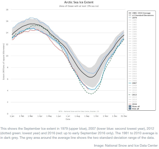
The latest data on Arctic sea ice extent suggests that 2016 might see the second lowest minimum extent, at least since satellites started observing Arctic sea ice extent in 1979.

On the top of the Arctic Ocean lies a cap of floating frozen seawater. Every year during the fall and winter months, it expands in area and thickness, reaching its maximum extent, usually between February and April. During the spring and summer months the sea ice melts and reaches its minimum extent sometime in mid-September.
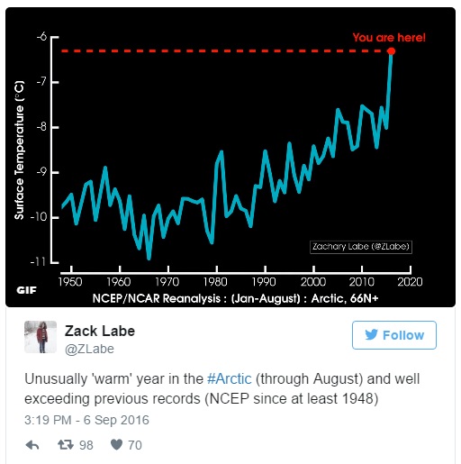
However this year has already been a year of records. On March 24, the maximum extent of sea ice in the Arctic peaked at 14.52 million square kilometers - a new record low. NASA scientists say that the maximum extent has become smaller and smaller over the last 13 years. A warm atmosphere probably contributed to the lowest maximum extent in this year, with air temperatures up 5.5°C (10°F) above average at the edges of the ice pack where sea ice is thin, said Walt Meier, a sea ice scientist at NASA’s Goddard Space Flight Center in Greenbelt, Maryland. Wind patterns in the Arctic during January and February were also unfavourable to ice growth because they brought warm air from the south and prevented expansion of ice cover. Meir added that what will likely play a bigger role in the future trend of Arctic maximum extents is warming ocean waters.
The year 2016 looked set to break all records for melting. Yet the cool summer slowed down the melting process. “This year has shown there is no correlation between what happens in May and September. May was the lowest ever, but 2016 did not end up the lowest,” said Julienne Stroeve, a senior scientist at the NSIDC and a professor at University College London. “The ice has definitely been thinner this year. Thinning ice is keeping the extent lower than it would otherwise have been.” As it also says in the National Snow and Ice Data Center monthly bulletin that two major storms in August helped to break up the ice and spread it out, which brought some of the ice into warmer ocean waters, hastening its melt. According to the NSIDC, the average ice loss rate through August was 75,000 square kilometers per day, compared to the long-term 1981 to 2010 average of 57,300 square kilometers per day.
As measured by satellite, the ice cap extent was 4.169 million square kilometers on 12 September, a slight increase from 4.139 illion square kilometers recorded on 11 September. The last record low sea ice extent in September 2012 was 3.41 million square kilometers. For comparison, in the 1970s, sea ice extent never dropped below 7 million square kilometers. As the NSIDC reports, ice extent is especially low in the Beaufort Sea and in the East Siberian Sea. However with about two weeks of seasonal sea ice melt yet to go, it is unlikely that a new record low will be reached before the end of the melt season.
Arctic sea ice minimums are declining at a rate of 13.4 percent per decade, according to Climate Central, which is much faster than the maximums (3.2 percent per decade). In addition, Arctic sea ice has been getting thinner, making it more vulnerable to melt. At hte moment, only 3 percent of the total ice cover is made up of ice that is five years old or older. Nowadays broken ice and open waters almost reach the geographic North Pole. Satellite imagery indicates that the broken ice and open water may even extend to 88 degrees North in some places. "It's creeping closer [to the Pole] every year", said Mark Serreze, the director of the National Climatic Data Center. He also called 2016 "another year in the new normal of the Arctic."
Various studies suggest that at some point the Arctic Ocean will lose its ice cover completely in late summer, however, nobody knows the exact date. “When it comes to predicting the timing of an ice-free Arctic, climate models show a large spread of over 100 years. Many studies have attempted to narrow this wide range, in some cases to as little as five years,” said Alexandra Jahn, an assistant professor in the University of Colorado Boulder’s Department of Atmospheric and Oceanic Sciences (ATOC).
Arctic melting, as clear evidence of climate change, has some serious consequences. The most important one is that as more ice melts, more ocean becomes exposed, and therefore more open water absorbs heat and warms up. Not only does it create a positive feedback loop making ice melt even faster, it also affects the ocean environment and currents such as the current known as the Atlantic Meridional Overturning Circulation, which brings warm water from the equator to the poles, and then shuttles cold water back to the tropics where the cycle starts all over again, as studies reveal. The changes in the Arctic Ocean temperature will affect this current and therefore the weather patterns all over the world, especially in Europe.
Another serious concern is possible methane emissions. "The Arctic also has massive stores of methane in the permafrost and sea bed," said Tom Wagner, manager of NASA's Cryosphere Program." As we lose the sea ice, we have more heat going into the ocean, causing more permafrost to die, which can destabilize the sea bed and trip the release of this methane, which could cause spikes in temperature." The Arctic Methane Emergency Group, AMEG, warns that in case of methane release on a large scale, "this situation can start an uncontrollable sequence of events that would make world agriculture and civilization unsustainable".
Polar bears and other animals are strongly affected by the changes in the Arctic ice extent, because they rely on sea ice for essential activities such as hunting, traveling and breeding. Sea ice loss may totally disrupt in the food chain and population, according to Eric Post, a Penn State University professor of biology, and an international team of scientists.
For shipping, oil extraction and tourism the sea loss gives some new opportunities, though. The disappearing Arctic sea ice could boost trade between north-west Europe and countries such as China, Japan and South Korea by making the sea routes far shorter, as economic analysts predict.

