High Temperature in the North – Cold in the south
- Details

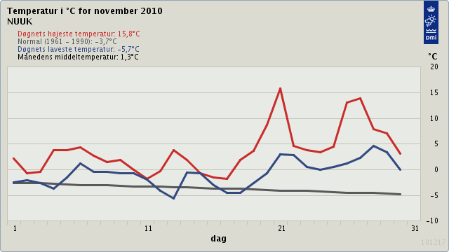
During November and the beginning of December, there has been unusual weather phenomenon over Greenland and Iceland causing unusual high temperature in the area. It is reported on the 29th of November that in the capital of Greenland, Nuuk, that the temperature was as high as 16° C (61°). According to the Danish Meteorological office, the mean temperature in November 2010 in Nuuk was 1,6° C (36° F), while the annual mean temperature in November is -3,7°C (25° F). So far in December, the mean temperature has been 1° C (34° F), which is seven degrees over the annual mean temperature, which is -6,2°C (21° F). This unusual high temperature has though not occurred in Iceland were the mean temperature was close to the annual mean. Still, the temperature went as high as 12, 4°C (11 °F) along the south coast. In December, the temperature at the south coast of the island went as high as 15° C (59 °F). Such high numbers in Iceland are not common in Iceland even though for the mean temperature is quite high, due to the Gulf Stream. However, this is unusual in Greenland.
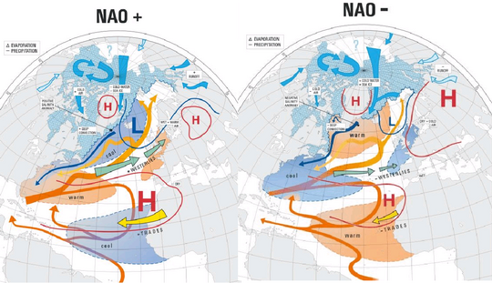
This unusual weather conditions might be explained with the so called North Atlantic Oscillation (NAO). This weather phenomenon in the North Atlantic Ocean is fluctuation in the difference of atmospheric pressure at sea level between Iceland in the north and the Azores in the south. There is a correlation between those two areas, meaning that when there is a high pressure over Iceland, there is a low pressure over the Azores and vice versa. The east-west oscillation motion of this pressure difference then controls the strength of the direction of the westerly winds which are the main cause for abnormal weather activity in the North Atlantic region and in Central Europe.

In November till April, the NAO is responsible for much of the variability of weather in the North Atlantic region, causing wind speed and direction to change, which further cause changes in temperature and moisture. When the NAO is positive it causes mild temperature in West and Central Europe and cool climate in Greenland and Labrador. When the NAO is negative it causes a shift, meaning that West and Central Europe becomes colder when it warms up in Greenland, Labrador and Iceland.
The winter of 2009-10 in Europe was unusually cold, especially during December, January and February and caused many inconveniences in the continent. It is theorized that this may be due to solar activity but this cold winter is also coincided with an exceptionally negative phase of the NAO.

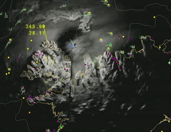
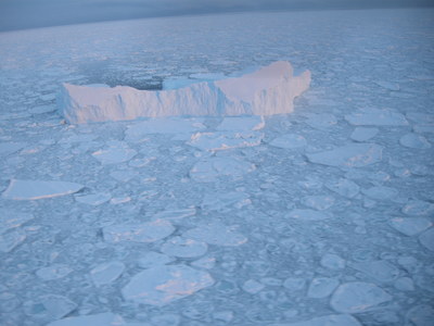
The NAO also causes changes in sea ice distribution at the east coast of Greenland. The NAO is in negative position, causing more westerly wind to blow. Also, the NAO generates better conditions for the sea is to formulate at the north east coast of Greenland. Du to this, a sea ice warning has been issued by the Icelandic Metrological Office in Iceland. According to surveillance of the Icelandic Coast Guard on the 9th of December the sea ice edge was around 20 nautical miles from the North west coast of Iceland. A day later, on the 10th of December, the sea ice edge was only 10 nautical miles from the shore. This is caused by a strong westerly wind, caused by the NAO, which blows sea ice into Icelandic waters. The sea ice has drifted further west into Icelandic waters but away from shore. However, with strong northern winds, the ice might reach shore at some northern peninsulas. This can cause inconvenience for sea-farers and fishermen since the sea ice can block the sea route North West of Iceland. Due to this, transportation of fish needs to be on land since vessels can be shut from the home harbour. The Ice is however sparse with denser ice in between. Five large icebergs have been also spotted and is the highest one estimated to be around 110 meters (360 feet). Such large icebergs are as not usual in this area. A reason for increased icebergs might be due to warmer climate. Warmer climate causes the ice-shelf around Greenland to weaken and break up, causing increased icebergs in adjunct waters.
The NAO phenomenon is negative position now, causing unusual weather in Greenland and somewhat in Iceland. However, the most of the inconvenience caused by the NAO occurs in Central Europe. The winter in Europe has been very cold so far in 2010 and is predicted to stay so until the beginning of the new year of 2011. This has been linked to the NAO, however, there might be another reason. For example, the Icelandic low pressure - which normally sits between to the west of Iceland and Greenland - has appeared regularly to the east of Iceland and so allowed exceptionally cold air into Europe from the Arctic. Together those two form a unusual weather conditions in the area. However, there is no doubt of an unusual and or a changing climate.

Sources:
Icelandic Meteorological Office
Danish Meteorological Institute
The Icelandic Coastguard
