Shipping Routes
Global climate change and melting sea ice, offers more and more opportunities for international transportation networks.
Notably, the trend of receding ice caps around the North Pole could possibly make the Arctic more reliable for scheduled navigation, at least during the summer months.
The Northwest Passage and the Trans-Arctic Shipping Route
The Northwest Passage, crossing the Canadian Arctic, is predicted to be used on a regular basis in the near future, cutting down the maritime shipping distance from East Asia and Western Europe substantially.
Currently, two sea routes have been defined to cross the Arctic, enabling ships to move between the Atlantic Ocean and the Pacific Ocean and thus have the possible status as an international strait (or waters) giving right to transit passage.
Both of them overlap significantly with the jurisdiction of either Canada or Russia, which can create certain legal difficulties if or when Trans-Arctic shipping becomes a reality.
Scientific data, to what extent the receding perennial ice cover is melting remains highly uncertain. Cargo shipping services around the Arctic Circle are very limited, as there is no possibility for the operators to drop off and pick up cargo as they pass through. This also limits the opportunity for the trans – shipment hubs to rise along the Arctic shipping routes.
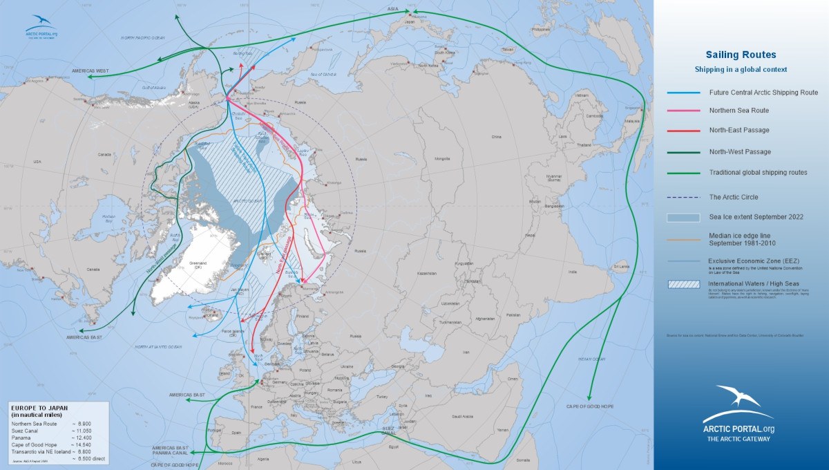
The Arctic Shipping Routes
In the shipping portlet, more information can be found on the Northwest Sea Route and the Northeast Sea Route, as well as the more distant possibility of the Central Arctic shipping route.
Click on the map above to view the current and future Arctic shipping routes. You can also access the Arctic Portal Arctic Data Management System and find Arctic shipping routes under Arctic Shipping in the drop-down menu on the left-hand side.
Source: National Snow and Ice Data Center (NSIDC) Map: Arctic Portal (to view more maps please visit our Map Gallery)