Arctic Islands
The Arctic is home to a remarkable array of islands—ranging from vast landmasses to remote volcanic outposts. These islands are not only ecologically and geologically diverse but also hold cultural, geopolitical, and historical significance. This section explores some of the most prominent islands in the Arctic region, showcasing their landscapes, wildlife, and unique features that contribute to the complexity and richness of the circumpolar world.
Diomede Islands
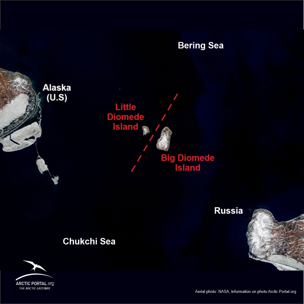 The Diomede Islands, named after the Greek explorer Diomedes, are located approximately 3.8 km or 2.4 miles apart at their closest point. Danish navigator Vitus Bering sighted the Islands on 16 August 1728, the day on which the Russian Orthodox Church celebrates the memory of the saint Diomedes, hence the name. In 1732, a Russian geodesist, Mikhail Gvozdev, determined longitude and latitude for the two islands.
When the United States purchased Alaska from Russia in 1867, it included Little Diomede or Krusenstern Island (Inupiaq: Iŋaliq). The island spans only 7.3 square kilometers. Big Diomede known as Ratmanov Island was not included in the purchase and therefore belongs to Russia. Subsequently, the two nations drew a boundary line between the islands. The passage between the islands has since been referred to as the “ice curtain”, a reference to politics rather than climate. During winter, an ice bridge usually spans the distance between these two islands, therefore at times it is theoretically possible to walk between the United States and Russia - although not legal since travel between the two islands is strictly forbidden!
See quick-fact on Diomede Islands
See also the article: The Diomede Islands – Tomorrow & Yesterday Isle
 Ellesmere Island
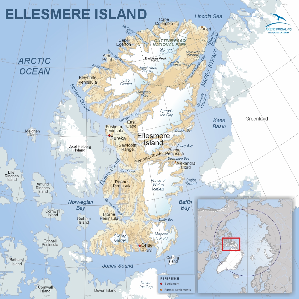
Ellesmere Island is the third-largest island in Canada and the tenth-largest in the world. Characterized by ice-covered mountains, deep fjords, and expansive ice shelves, it stretches approximately 830 km long and 645 km wide, covering an area of about 196,235 km2. Barbeau Peak, the island’s highest mountain and the highest point in Nunavut, rises to 2,616 m.
Quttinirpaaq National Park, located in the northeastern corner, is one of Canada's most remote protected areas and the second-most northerly park on Earth after Northeast Greenland National Park. The park’s name means “top of the world” in Inuktitut.
About 40% of Ellesmere Island is glaciated, making it one of the most heavily glaciated regions in the Canadian Arctic. Despite its icy landscape, it is also one of the driest parts of the Arctic, with a desert-like climate and sparse precipitation.
Though largely uninhabited today, population in 2024 according to the World Population Review was 144. The island has a few settlements and research stations.
See quick-fact on Ellesmere Island
See also the article: Ellesmere Island: The Remote Arctic Frontier
 Faroe Islands
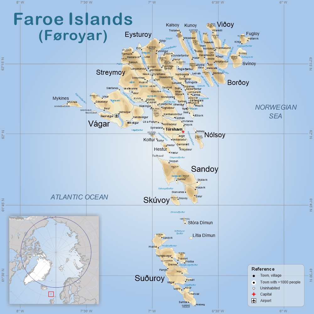
The Faroe Islands are an autonomous territory of the Kingdom of Denmark. They consist of 18 rugged islands situated between the Norwegian Sea and the North Atlantic Ocean, roughly halfway between Iceland and Norway. Covering an area of 1,393 km2, the islands feature Europe’s highest sea cliffs, fjords, green hills, and over 1,100 km of coastline.
The highest point is Slættaratindur at 882m on the island of Eysturoy. Tórshavn, the capital located on Streymoy Island, is home to about 23,000 people. The official language of the islands is Faroese.
Despite their high latitude, the climate is moderated by the Gulf Stream, leading to cool summers, chilly winters, frequent fog, and strong winds.
The weather in the Faroe Islands is famously unpredictable, with sudden changes that can bring sunshine, rain, and fog all in one day.
See quick-facts on the Faroe Islands
 Greenland
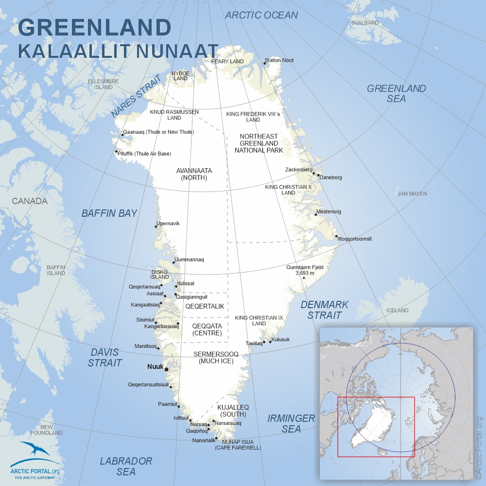
Greenland is the world’s largest island, covering about 2.17 million km2—roughly 20 times the size of Iceland. Around 1.76 million km2 is covered by ice and glaciers. The coastline stretches for approximately 39,330 km, making it one of the longest in the world. The island’s highest point is Gunnbjørn’s Fjeld at 3,693 m.
Roughly two-thirds of Greenland lies above the Arctic Circle. Its coastal zones host tundra ecosystems, with permafrost underlying much of the terrain. The northeast section is home to the world’s largest national park—the Northeast Greenland National Park—covering nearly 972,000 km2.
Greenland’s coastal waters support marine mammals like seals, walruses, and whales. On land, polar bears, Arctic foxes, reindeer, wolves, and musk oxen roam. Over 230 bird species, including sea eagles and puffins, nest along its coasts and feed on the region’s fish-rich waters.
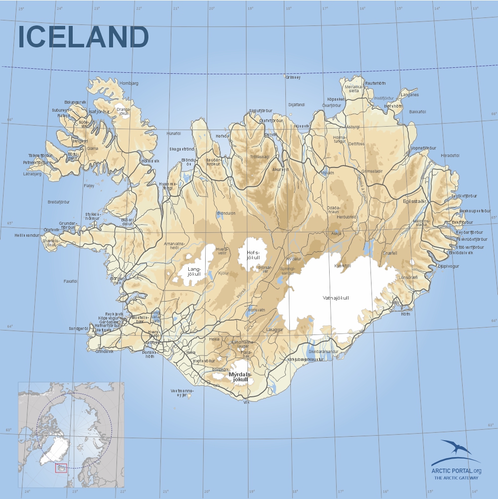 Iceland
Iceland, the second-largest island in Europe, spans 103,000 km2 and lies atop the Mid-Atlantic Ridge. It’s known for volcanic and geothermal activity, with numerous geysers, hot springs, and lava fields. About 10% of the island is glaciated, and over 50% is barren. The fertile areas mainly lie along the southern and western coasts.
Thanks to the North Atlantic Current, Iceland enjoys a relatively mild climate compared to other places at similar latitudes. Coastal waters remain ice-free year-round, and the Gulf Stream helps regulate temperatures, although occasional shifts in ocean currents can lead to more extreme weather.
The population of Iceland is about 390,000 (2025).
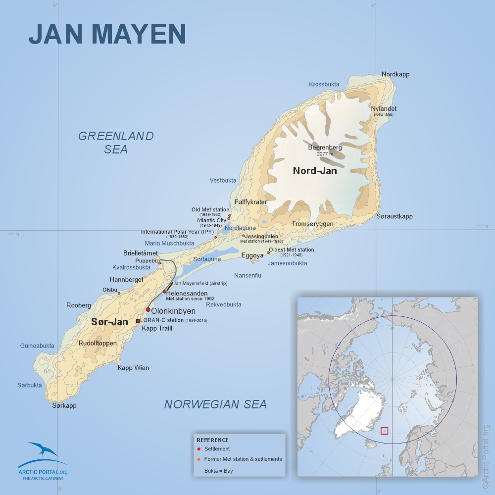 Jan Mayen
Jan Mayen is a remote volcanic island under Norwegian jurisdiction, located at 71°N, 8°W. It lies roughly 600 km northeast of Iceland, 500 km east of Greenland, and 1,000 km west of mainland Norway. The island is about 55 km long and covers 373 km2.
The island’s dominant feature is Beerenberg, the northernmost active volcano in the world, which last erupted in 1985. It rises to 2,277 m and is glacier-covered. The flatter southwest part of the island, Sør-Jan, lacks glaciers. The island is named after Jan Jacobszoon May, a Dutch sea captain who visited in 1614.
Jan Mayen has been a nature reserve since 2010 with strict visitation regulations. There is no permanent population on the island, only personnel.
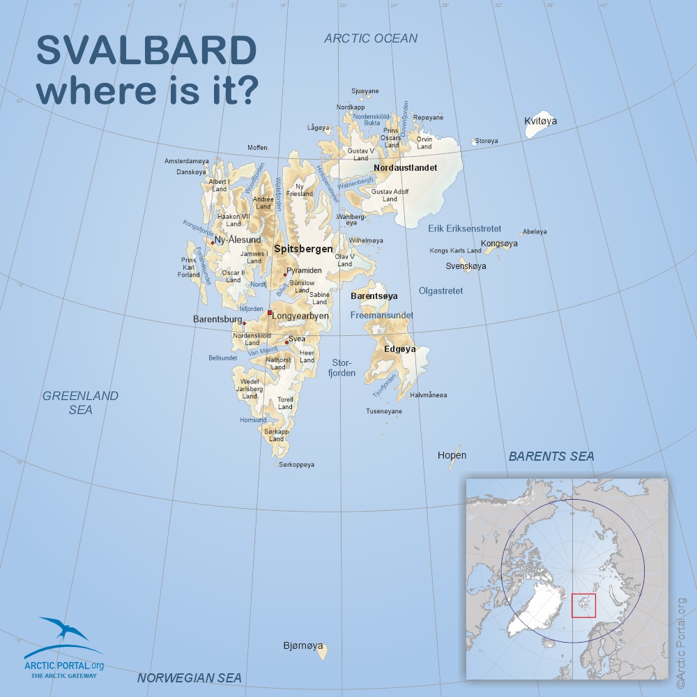 Svalbard
Svalbard is a Norwegian archipelago situated between 74° and 81° N latitude. It covers 62,700 km2, with most settlements clustered on Spitsbergen Island. The largest settlement, Longyearbyen, has around 2,400 residents from over 50 countries. Other settlements include Barentsburg, Ny-Ålesund, and the meteorological outposts on Hopen and Bjørnøya.
Svalbard’s landscape features towering mountains, glaciers, and Arctic tundra. The region hosts a wide range of Arctic wildlife, including polar bears, reindeer, walruses, beluga whales, Arctic foxes, and numerous seabird species such as guillemots and puffins.
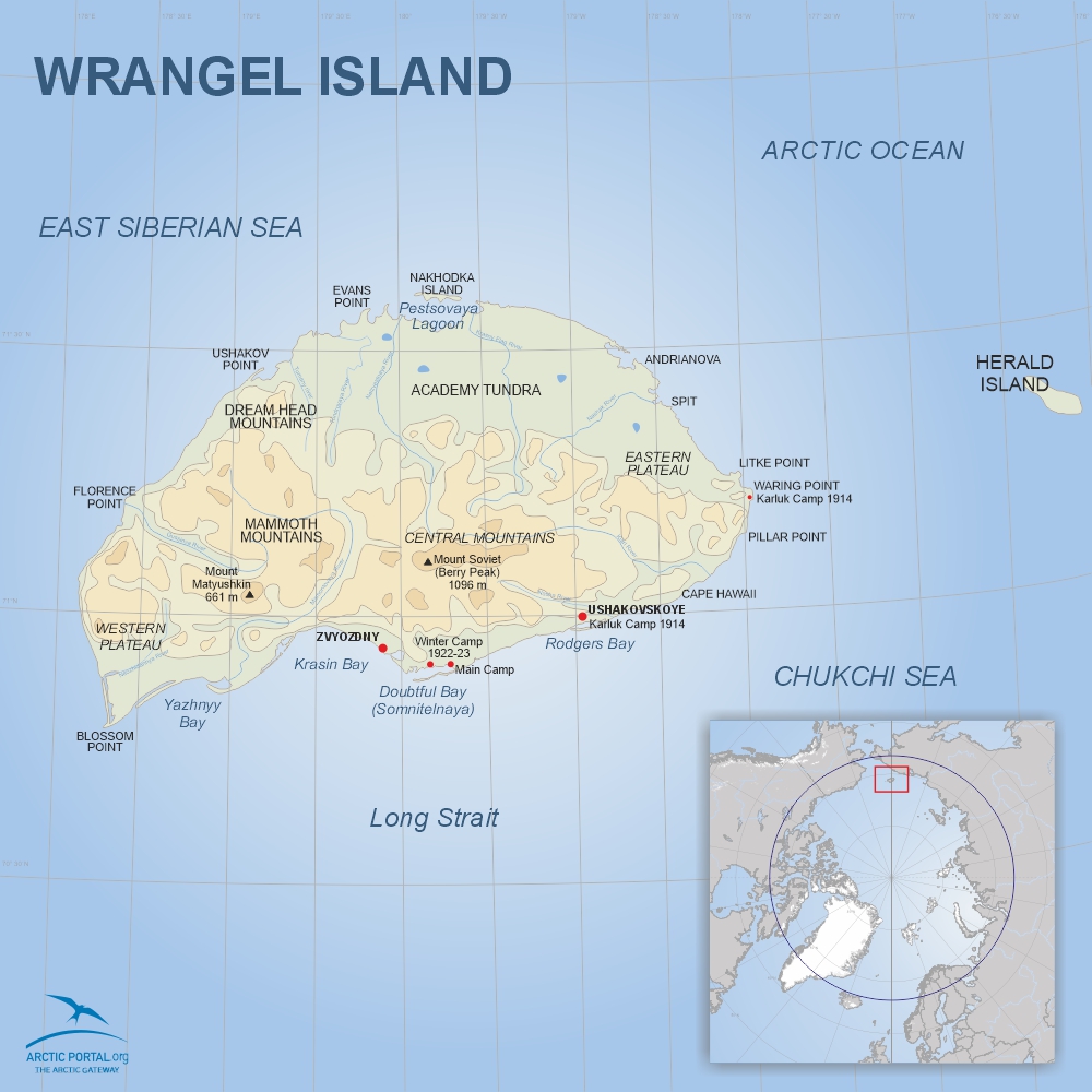 Wrangel Island
Wrangel Island lies at around 71°N, 179°W, off the northeastern coast of Russia. It is about 150 km long and 80 km wide, with a total area of 7,600 km2. Unique among Arctic islands, it remained unglaciated during the last Ice Age, preserving ancient ecosystems and soils largely undisturbed for millennia.
The island supports over 400 plant species—the richest Arctic island flora—along with a variety of endemic wildlife. Its preserved tundra ecosystems provide insights into the Pleistocene epoch. Wrangel is also a critical habitat for polar bears, walruses, and migratory birds.
See quick-facts on Wrangel Island
Wrangel Island: Land of Mammoths, Explorers, and Polar Bears
See map of Wrangel Island